// the model I built from scratch

Macro-HyProS

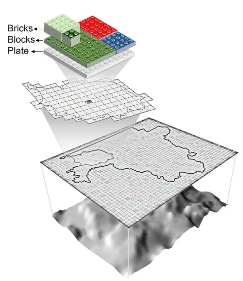
A Macro-scale Hydrologic Processes Simulator for cold-climate, depression-dominated regions, written from the ground up in FORTRAN and Python during my PhD (NSF and USGS funded). It is a grid-based, daily model with a "LEGO-fashion" layout that handles sub-grid land-use variation, five stacked vertical bands (atmosphere, vegetation, snow, surface, sub-surface), and improved methods for snow, frozen ground, and surface depressions. Tested on the Red River of the North Basin, it reached Nash-Sutcliffe efficiencies of 0.56 in calibration and 0.72 in validation, and showed that the basin spends about 145 days a year with frozen or partially frozen ground.

FORTRAN + Pythongrid-based5 vertical bands snow and frozen grounddepression-dominated terrain
BRICKSBLOCKSPLATE
Macro-HyProS represents each grid as a "plate" carrying stacked land-use "blocks" and "bricks" (after Fig. 1 of the Journal of Hydrology paper).
// journal articles · 13

Peer-reviewed journal articles

  1. 2024

    Daily soil temperature simulation at different depths in the Red River Basin: a long short-term memory approach

  2. 2023

    Impacts of temperature data sets on macroscale snowmelt simulations in the Missouri River Basin

  3. 2023

    Uncovering the depletion patterns of inland water bodies via remote sensing, data mining, and statistical analysis

  4. 2022

    Impacts of seasonally frozen ground on streamflow recession in the Red River of the North Basin

  5. 2021

    Do sub-daily temperature fluctuations around the freezing temperature alter macro-scale snowmelt simulations?

  6. 2020

    Macro-HyProS: a new macro-scale hydrologic processes simulator for depression-dominated cold climate regions

  7. 2019

    Macro-scale grid-based and subbasin-based hydrologic modeling: joint simulation and cross-calibration

  8. 2018

    SWAT modeling of non-point source pollution in depression-dominated basins under varying hydroclimatic conditions

  9. 2018

    TWI computations and topographic analysis of depression-dominated surfaces

  10. 2017

    A new depression-dominated delineation (D-cubed) method for improved watershed modeling

  11. 2017

    SWAT modeling for depression-dominated areas: how do depressions manipulate hydrologic modeling?

  12. 2016

    How does DEM resolution affect microtopographic characteristics, hydrologic connectivity, and modeling of hydrologic processes?

  13. 2015

    Simulation of water surface profile in vertically stratified rockfill dams


// conference presentations · 5

Conference presentations and proceedings

  1. 2019

    Macro-scale hydrologic modeling for depression-dominated cold climate regions

  2. 2018

    Topo-statistical analyses of ponding area versus ponding storage of depression-dominated regions for macro-scale hydrologic modeling

  3. 2017

    Scale analysis for depression-dominated areas: how does threshold resolution represent a surface?

  4. 2016

    Modeling of subsurface drainage under varying microtopographic, soil and rainfall conditions

  5. 2015

    DEM-based watershed delineation: comparison of different methods and applications


// book chapters · 2

Book chapters

  1. 2022

    Decision tree (DT): a valuable tool for water resources engineering

  2. 2021

    Conflict resolution: the gist of the matter in water resources planning and management


// also

Dissertation

  1. 2019

    A new macro-scale hydrologic processes simulator for depression-dominated cold climate regions

Where a DOI exists, the title links to it; otherwise it links to a Google Scholar search. The full list with citation counts is on the Scholar profile. The modeling work behind several of these is described on the projects page.